




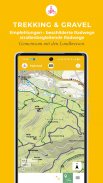

KartoGuide Harz

Описание на KartoGuide Harz
This app only works on subscription. You are welcome to try the app at a discounted introductory price.
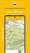
Explore the Harz with lovingly designed, rich in content and locally produced maps for hiking, mountain biking, cycling, gravel biking. Over 270 tour suggestions offer easy access to the extensive network of trails in the Harz Mountains.
The right cards for your activities:
- Basic map for purists
- Hiking map with signposted paths and other recommendations
- MTB map with trail levels and descriptions (only Hochharz)
- Bike map for touring bikes and gravel bikes
The KartoGuide Harz is the ideal companion for individualists in the Harz Mountains. The maps show the signposted network of hiking and cycling trails as well as other trails that are suitable for hiking and cycling, as well as the level of difficulty for mountain biking.
Be inspired by our tour suggestions and discover the area on your own.
roadblocks
We record temporarily blocked paths on the maps and update this information regularly.
Seek
Our search function will help you to quickly find stamp locations, names of mountains and cliffs, sights and many other prominent points on the map.
25 years of experience
We have been drawing leisure maps for the Harz Mountains for over 25 years. This experience is an integral part of building and designing our digital maps. As outdoor enthusiasts, we also research our information on site and pass it on to you directly with our maps.
Interplay with our printed maps
Despite digital technology and a dynamic display, the maps in the app are kept in our own style. Hybrid navigation with map and smartphone becomes a convenient interplay for you: swap the medium – not the content!
Our map content:
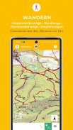
- Signposted main hiking trails as a dashed red line with numbering and marking
- Marked circular hiking trails as a continuous red line
- Other hiking trails as a red dotted line, some with hiking symbols
- Theme and long-distance hiking trails as a colored line with name and symbol such as Harzer Hexen-Stieg, Harzer Grenzweg, Selketal-Stieg, Harzer Baudensteig, Karstwanderweg, Südharzer Dampfloksteig, Teufelsstieg, Harzer Klosterwanderweg
- all 222 stamping points of the Harzer Wandernadel project with name and number
- Shelters, rest areas and barbecue areas, vantage points, camping and mobile home sites, youth hostels, sights, indoor and outdoor swimming pools, golf courses and tennis courts, climbing and bike parks, horseback riding, ski lifts, toboggan runs and much more
- Signposted cycle paths as a light purple line such as Harzrundweg, Ilse-, Holtemme- and Innerste-Radweg, Iron-Curton-Trail, Mountainbike-Arena Harz, Devils Trail
- Bike recommendations as a dark purple line
- cycle paths along the road as a dotted line
- MTB recommendations as a green line
- Signposted MTB trails as a green dashed line
Scale-variable and sheet-cut-free
With the subscription, the entire Harz region is available to you in the app without any page cuts. You can move around the map without limits, zoom continuously and rotate the map.
Get started right away with our tour suggestions
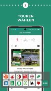
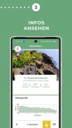
With more than 270 tours, you can start straight into the Harz wilderness and cultural landscape. The tours can be combined with the maps – basic map, hiking map, bicycle map, MTB map.
Location - walking direction - offline use
Where am I? Let the app show your location.
Where are you going? If your smartphone has an integrated compass, the map rotates in the direction you are walking.
No net? Take precautions! Load the map data onto your smartphone with a WiFi connection and use the app offline.
Hints:
Terms and Conditions: https://www.schmidt-buch-verlag.de/allgemeine_geschaeftbedingungen/
Data protection information: https://www.schmidt-buch-verlag.de/datenschutz-app/


